
I was about six the first time I remember seeing Oregon Trail tracks. My mom pointed them out as we drove along I-84 near the Idaho border. Even at that age, I didn’t have to ask what the Oregon Trail was; I already knew. I was even impressed enough that I still remember the moment. Possibly it’s from growing up here—I’m pretty sure Oregon kids absorb Trail information by osmosis.
Tracks from the emigrant trains aren’t that hard to see in Eastern Oregon. The “trail” comprises many different trails, roads, and cutoffs (so named because they were supposed to cut miles off the trip), so where there’s less annual precipitation, the deeply cut ruts survive for decades.
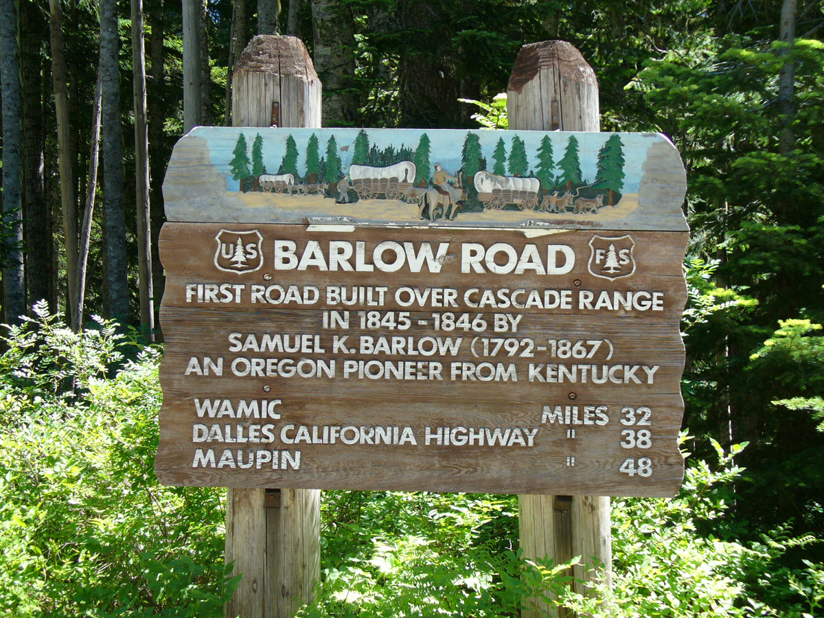
In Western Oregon, though? There’s only one place on the west side of the Cascades claiming visible ruts from the wagon trains, and that’s on Barlow Road. When I say “west side,” I mean the location barely qualifies as western. It’s a mile west of the high crest of the Cascade Range.
Specifically, these western ruts can be found on the Barlow Trail, which meets up with the Pioneer Woman’s grave.
The Pioneer Woman’s Grave is on old Highway 35, AKA Forest Road 3531, south of Mt. Hood Meadows. It’s a 1-1.25 hours’ drive east of Portland, only 35 miles southwest of Hood River (on new highway 35), and about 115 miles northeast of Salem. From the main road, there’s a handy brown sign pointing the way to the gravesite. However, I’ll delve into directions and logistics later; for now, let’s discuss what there is to see and do here.
The actual Pioneer Woman’s Grave is underwhelming. It’s a cairn of rocks on the side of the old highway with an interpretive sign next to it. The story of it is more interesting than the sight of it. The woman’s grave, marked by an old wagon tongue, was found in 1924 by crews building the original highway. Oral histories at the time claimed she was survived by a husband and two young children, who buried her here in the 1840s and then continued on the trail to the Willamette Valley. No one stepped forward to claim her as an ancestor when the news hit the media at the time, so she remains unidentified to this day.
One interesting aspect of visiting the grave is the unusual collection of items left behind by visitors. This site has a number of pictures that illustrate some of the offerings, although the person who wrote the post is clearly not a fan of the practice.
Across the road (east) from the grave, with a modicum of hunting, you can find the wagon ruts. Follow the modern (ish) road a little north until it crosses a stream, and then walk a couple of dozen yards into the forest to see where the Barlow Road builders cut into the native rock so that wagons could follow an easy ramp down to ford the creek.
Or let the arrows and sign spray-painted onto the old highway guide you towards the Barlow Road itself, and follow that north.
When crossing streams with high banks where there wasn’t a graded ramp down to the water, pioneers had to lower the wagons on ropes on one side, ford the river, and then raise the wagons via ropes to the other side. It was a lot of work and could take a large train of wagons multiple days to complete on larger crossings. Barlow Road was a toll road, but it’s easy to understand why people were willing to pay to use it, not only because of the graded crossings but because the roadway was kept clear of trees and brush and didn’t require turning a wagon into a raft and floating down a giant, somewhat treacherous river.
As for the actual ruts here … well, calling them ruts is a bit generous. You have to hunt to see them, but the wagon ramp is easy to find, and it’s very easy to follow the actual Barlow Road a ways. Up to this day, nothing larger than a small bush grows where the road is. The emigrant traffic on it so compacted the earth beneath it that it became rock-like, a tough place for roots to get a toehold. For younger children, this is a great way to immerse them in a forest environment. It’s a largely easy walking surface but has the atmosphere of wandering through a trackless wilderness.
But wait, there’s more! As in, there’s a hike—Pioneer Woman’s Grave Trail #485—between the grave and the point 465 feet above it, where the Barlow Road and the Pacific Crest Trail converge. Officially, the trailhead is on the eastern terminus, at the high point, although there’s a small parking site near the gravesite end. The hike is just over a mile one way, and it’s rated as “easy” on the Oregon Hiker site. You’ll have to decide for yourself how easy a nearly 500′ elevation gain in a mile really is for your kids.
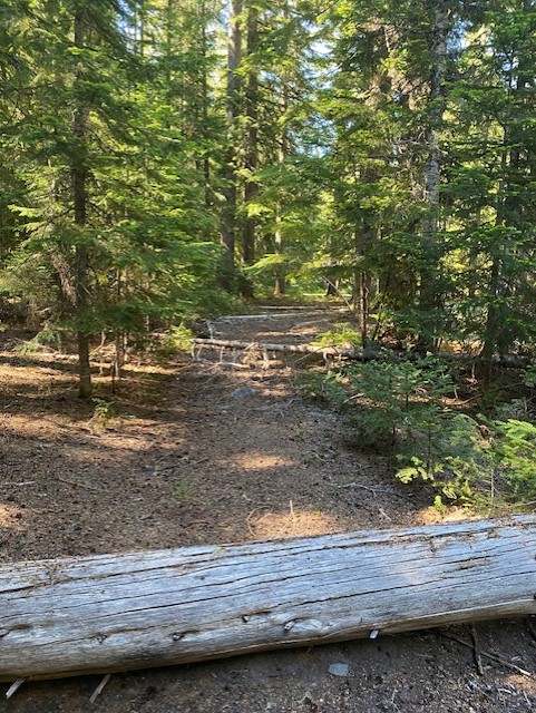
Full disclosure: I decided that kind of elevation gain wasn’t for me. Instead, I followed the historic highway by car to the top of the trail—the original Highway 35 is preserved in a loop that begins and ends at the modern highway. This loop road has its sites of interest, but it’s worth remembering that it’s now a Forest Service road and is maintained accordingly. When I most recently drove it, a tree had fallen across the route and had only been partially cleared, forcing me into the opposite lane of traffic. Since there’s very little traffic anyway, that was more amusing than annoying.
Driving this loop, you’ll get beautiful views, but it does comprise a lot of twists and turns, so kids prone to car sickness may not appreciate it. About midway along is a perfect vista of the south side of Mount Hood. There’s a pullout here for stopping and spectating, and across the road from it is a spring-fed fountain with water freshly percolated up from the ground. This makes it purportedly drinkable.
Continuing, you reach the official trailhead at Barlow Pass. In the parking area, there is a toilet, along with scattered signage that tells you about the various trails. The route to the gravesite begins at the lot on the north side. If you head a little east along the old highway, you’ll find both the Pacific Crest Trail and the Barlow Road crossings. You can hike in either direction. My husband and I hiked along the PCT for about a mile so that we could say we did it (and then text a friend who has through-hiked the PCT several times. He was unimpressed with our efforts). There are native wildflowers and berries—notably huckleberries—alongside the trail and road.
Across from the parking area is a picnic table. The PCT has become well-trafficked in recent years, and this table is right on the trail, so in the hiking season, it’s more likely to be occupied than not. If a picnic is part of the plan, it’s probably best to make other arrangements for an eating surface.
To visit the gravesite and trails, the only thing you truly need is a car and a Northwest Forest parking pass, an interagency pass (like the America the Beautiful card), or a $5/day parking pass ($4 in winter). Get details on buying any of those here, or stop at a Forest Service office on the way.
Reaching the area is relatively easy and primarily scenic, offering dramatic views of the surrounding mountains and rock formations. Sandy is an excellent place to make a stop along the way, especially if coming from the west (Joe’s Donuts!), and a visit to charming Parkdale is a very short side trip from the east side. If you are coming from the east, take 35 from Hood River. The trailhead is on the left, just after milepost 60, and the gravesite is a couple of miles farther west.
Coming from the west, the best approach is to follow Highway 26 until it merges with Highway 35. It’s only a bit beyond that where you make a right onto the old highway at the sign for the grave. If you want to start at the trailhead and PCT/Barlow Trail crossings, continue along 35 to about milepost 60 and turn onto the eastern end of the old highway loop road.
The area isn’t overly crowded, even on a weekend—down by the Pioneer Woman’s Grave, it’s even less so—and it’s not only beautiful but is considerably cooler than in the valley or city. Plus, it has many of my favorite things: history, native flora, incredible scenery, and a very Oregon atmosphere.
When it hits the upper 90s, and we’re wondering what to do, a field trip here makes a great, chill outing.
