In my last post, I discussed a couple of sites—Beacon Rock and Cascade Locks—to visit in the western part of the Columbia River Gorge, with an eye toward getting kids to really explore the physical world that surrounds them rather than virtual worlds.
Those places are only two of many in this national scenic area, and while it’s tempting to write multiple posts about the various interesting sites in the Columbia Gorge, I do have other things I want to write about at some point, so … I’ve restrained myself (with much difficulty) to only a couple of installments.
My personal favorite spots to visit in the gorge are in the eastern part, and I’m going to cover a few in and near The Dalles today.
I think The Dalles often gets missed by many people coming from the West because the famous place to stop (and often the destination of many people) is Hood River. It’s understandable—it’s a great place to hang out for a day or a weekend, but it’s been written about far and wide, and much of what you see in Hood River now sprang up in the last few decades. As a history buff, I eschew towns with much of their past obscured.
Plus, I don’t windsurf or kiteboard. My ideal water sports are snorkeling and floating down a river in an inner tube.
But enough about me.
This itinerary begins by taking the Mosier exit from I84 and following old Highway 30 into The Dalles. In case you don’t know, when Highway 30 was extended east from Troutdale, it was the first road built for motorized vehicles through the gorge. Construction began on this roughly 75 mile-stretch in 1913 and didn’t reach The Dalles until 1922. It’s an engineering masterpiece for that time. I could write a whole post on that, but I won’t. Check out Wikipedia for a wealth of detail to bore your children with as you drive the old sections.
There are two existing sections of the Historic Columbia River Highway, and driving part of one will give you an idea of what obstacles those early road builders had to overcome. The old wagon road it replaced had grades of 20% or more. Note that both parts are famous for twists and turns, so you might want to miss it if you have any passengers prone to car sickness.
The western section runs from Troutdale to Cascade Locks. It’s an exciting drive that passes numerous waterfalls, including Multnomah Falls, but it’s heavily traveled. When I last drove it in the spring, sections along it seriously needed work.
The 16-mile route from Mosier to The Dalles tends to have less traffic and is generally in better shape. It’s also easily as scenic as the western end. Can you tell this is my preferred route? Let me illustrate why.
East of Mosier, a few miles (well, eight-ish miles), is the tiny hamlet of Rowena. Driving further east from there will shortly bring you into the boundaries of the Tom McCall Preserve, a great place for you and your kids to connect with nature, although not the family dog—pets aren’t allowed in this natural area. The preserve is most famous for its scenic views and wildflower meadows (best viewed from March to June). There’s also a fair amount of wildlife in the area, including the meadowlark, Oregon’s state bird. You can find trails that snake through this plateau in two locations. From them, you’ll definitely see amazing views, possibly some animals, and probably some flowers when it’s not too cold—there are flowers still in fall and very early spring. The first trail starts at a gravel parking area on the left/north side of the road. You can get a lot of views by just going a short way along the trail, or really, just beyond the trees screening this gravel lot, so smaller kids don’t have to over-exert themselves.
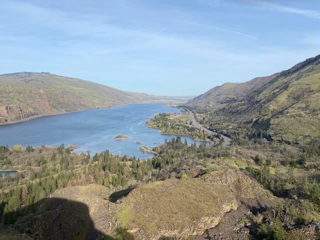
If you only want to make one stop at the preserve, skip this westernmost one and continue along Highway 30 to the Rowena Loops. You’ll know when you hit the loops, trust me (and see the note about car sickness). This historic highway section intentionally mimics the area around Crown Point, further west. There’s no historic building when you reach Rowena Crest, but there’s one of the very best views of the gorge I’ve ever found. The parking area at Rowena Crest viewpoint doubles as the beginning of another trailhead of Tom McCall Preserve. It begins just on the other side of the road from the parking lot, crossing through the largest meadow in the natural area. It’s a straightforward trail here and gives you even more of what you can see at the other spot.
Even if your kids aren’t into nature hikes, stopping at Rowena Crest is worth it for the views and for the interpretive signage, which explains not only some of the saga of building the highway but also what the architect of the project envisions for this area. If you want to front-load trivia to dazzle your kids with once you reach the crest, this is a good place to start.
East from Rowena Crest is one of the twistiest bits of the historic highway, pretty much out-looping every other bit. It also has some interesting roadside geology, mainly in basalt, and I’ve often seen deer while driving the Rowena Loops.
If you need refreshment once you reach The Dalles, on the east end of downtown, you’ll find Dinty’s Market West (806 E 2nd St), a mom-and-pop gas station that serves Umpqua ice cream and has great sandwiches, not to mention a ton of snacks and a few souvenirs and oddments. Across the parking lot from Dinty’s is Holstein’s Coffee if you need a latte. It’s my favorite coffee shop in town. There are more formal eating establishments of all types, from microbreweries to Cousins Restaurant on the west end of the city, which is something of a local institution. There’s even an attached hotel, the Cousins Country Inn.
The old downtown reveals the historic significance of this small city. There are many late-19th to early-20th century public buildings still existing, not to mention all the historic homes. A lot of them are constructed with stone and were intended as showpieces. Here’s a list of all the recognized historic buildings in Wasco County, most of which are in The Dalles.
The combined sight of these buildings reveals that here was a very successful frontier town. Much of this was due to its location: it was the last town before the Columbia Gorge, which made westward travel extremely difficult. This was the launch point for Oregon Trail pioneers who chose the river route and for barges loaded with agricultural products. The Lewis and Clark expedition spent some time here, at the Rock Fort Campsite, which you can visit.
The Fort Dalles Museum and Anderson Homestead (500 W 15th St & Garrison) is suitable for a wide range of kids with its original log buildings and park setting. There’s a vast variety of antique agricultural and logging vehicles and some other miscellaneous equipment. Only a couple of buildings still exist from this former military fort, and the museum in the surgeon’s quarters will explain a lot of that history.
The Anderson homestead buildings are across the street from the fort site. These are log original structures moved to the site from 25 miles southwest.
If your kids aren’t that into the Old West, The Dalles may just encourage them to develop an interest in it. I’ve barely scratched the surface of the history on offer here. A quick internet search will reveal more.
For the kids into science, there’s The Dalles Dam. If any dams can be said to be pretty, this isn’t one of them, at least in my opinion; your mileage may vary. But it has the advantage over some dams to the west in that it’s easier to see the component parts, even from the freeway. Next to the dam is an exciting park. The dam’s visitor center is open Friday through Sunday from 9-4 until October.
If all of that’s not enough for you, let me encourage you to travel just a little farther east along I84 to Biggs Junction. Between The Dalles and Biggs, you’ll cross the confluence of the Deschutes River and the Columbia, where there’s a state park and an Oregon Trail marker. In Biggs (mostly a huge truck stop), there’s another Dinty’s Market, complete with sandwiches and ice cream. Take a left at the light (after you’ve taken a right from the off-ramp), and it’s on your left.
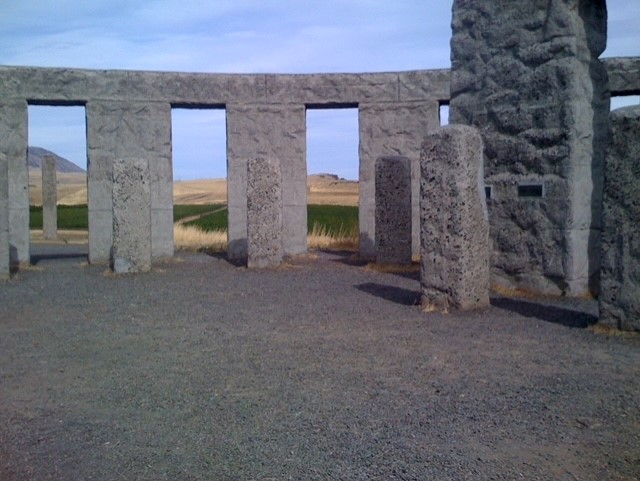
Biggs Junction is where Highway 97 crosses the Columbia. If you cross the Columbia and take a right onto the Maryhill Highway (SR 14, which I also spoke about in my last post), you’ll be able to see the Maryhill Stonehenge Memorial. Yet more great views of the Columbia can be found if you stop here, but the real draw for me is the henge itself. Much like the real thing, it’s just incredible. It’s not as grand or ancient, but I remember stopping here as a kid and being impressed.

If you have older kids who are into art (or if you’re into art and you can convince your kids to let you visit), the Maryhill Museum is worth a stop. Maryhill is the former estate of Sam Hill, and you can stroll the grounds here as well. Another thing you can see is the Maryhill Loops. Sam Hill was a modern (for his time) roadbuilding technique enthusiast, and at his own expense, he built the first paved road in the Pacific Northwest. In 1913, about the same time as construction of what’s now historic Highway 30 began, he invited the Oregon governor and legislature out to see his experimental road and showcase his results. Coincidence?
I can’t find any information on whether the Maryhill Loops influenced the Rowena Loops or Crown Point (although I didn’t really look that hard), but if you ask me, I can’t see how they didn’t inform the highway construction.
Regardless, I believe I’ve come full circle on the Columbia Gorge.
